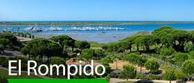
The 23 festivals you can’t miss in Andalucia
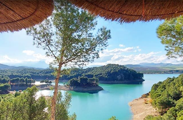
Small, calm and wild, El Chorro is a town within the town of Álora in Malaga, within the region of Antequera. Next to a dam on the Guadalhorce river, its peculiar geography, marked by Los Gaitanes Pass, defines an interesting profile of the village, hidden in this wonderful setting.
Its steep walls and wild forms have turn El Chorro into a very popular place for rock climbing lovers who find challenges in their walls. The site has been internationalized with the reopening of Caminito del Rey. Very important magazines and tourist guides around the world place it as a must for travellers eager for unique routes.
Near Antequera and Malaga, El Chorro is a good area to hide and enjoy nature in all its majesty, practising our favourite sports and activities.
We tell you about all you need to know about the surroundings of Caminito del Rey so you do not miss anything:
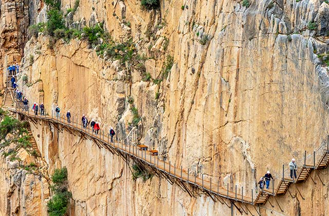
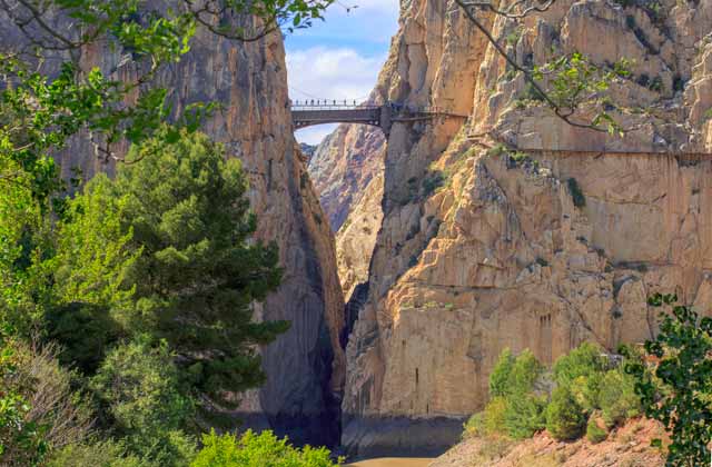
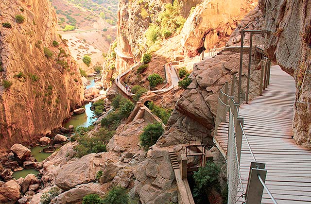
If we have to highlight something about this impressive place, it would be Caminito del Rey, a passage hanging from the side of the mountain which is quite steep in some parts. We are talking about a passage of no more than one meter in width located approximately 100 meters above the ground.
The characteristic path originated early last century due to Chorro Hydroelectric Society’s need to open a passage for the workers dealing with the maintenance and transport of materials. Tthe passage was built between 1901 and 1905. However, it was not until 1921, when King Alfonso XIII walked it to open the Conde del Guadalhorce Dam, a time when it began to be known by the nickname of Caminito del Rey.
While this road has been closed for a long time because of being considered dangerous, it has been rehabilitated and opened to the public since March 28, 2015. The total length of the passage is 7.7 kilometres, out of which 4.8 kilometres are entrances and 2.9 kilometres are walkways. Do not hesitate to visit it but remember you have to book quite some time in advance on http://www.caminitodelrey.info/es/
Natural Ppark Desfiladero de los Gaitanes is surrounded by three regions: Guadalteba, Antequera and Valle del Guadalhorce.
Los Gaitanes Pass is a canyon carved by the Guadalhorce River, a place that has a unique natural environment, an enclave of extraordinary geomorphological interest and one of the most impressive parts of the province of Malaga.
The dimensions of this narrow canyon more than 3 kilometres long are really impressive. In some sections, the width between its sides barely exceeds ten meters, which is even more impressive considering that in some places the height of the top of the river reaches 700 meters.
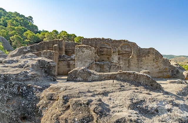
In the vicinity of Los Gaitanes Pass, on a sandstone plateau known as “Mesas de Villaverde” one of the most troubled cities of medieval history settled during the IX and X centuries: Bobastro.
The capital of the Moorish revolt against the Cordoba state, was the refuge of leader Omar ben Hafsun, where he harassed the emirate and agreed pacts with local governors, until he gained many allies among the people of the mountains of Malaga.
The people who visit the ruins of Bobastro can learn from its history and the legend of this Christian revolt that kept in check the emirs of Córdoba. Among the many rock buildings dug into the rock you will recognise military buildings, houses, caves and religious buildings.
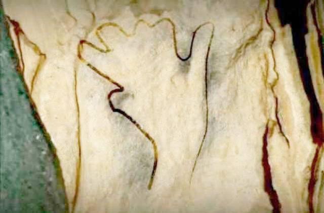
Also known as the Cave of Ardales, it is a cave located in the municipality of Ardales. It is a prehistoric site with Palaeolithic cave art. It was discovered in 1821 thanks to an earthquake that opened the actual door. Trinidad Grund acquired and conditioned it for her visit in the mid-nineteenth century, as an addition to its thermal business she had set up in the neighbouring town of Carratraca.
The Cave keeps more than 50 figures and other symbols belonging to the Upper Palaeolithic period (Solutrean and Magdalenian, 18000-14000 a. C.) almost all located in the Gallery of Calvary. The path inside the cave is more than 1.5 km, where the Big hall, Archer Gallery, the Lake room, the Ram Gallery, the Gallery of Prints and the Hands room really stand out. Here we will also come across mazes made with pillars, permanent lakes and beautiful formations of stalagmites.
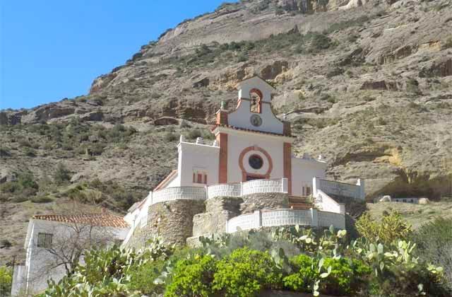
The Shrine of Nuestra Señora de Villaverde is squeezed between the Tajos Almorchón and the vertical walls of Mesas de Villaverde, where the Christian village of Bobastro once stood. Alongside the current chapel, renovated during the sixties last century, a necropolis of anthropomorphic tombs carved into the rock was discovered, and opposite the shrine a promontory which preserves the remains of a watchtower, known as Peñón del Moro, indicating the great importance of the enclave. The old shrine was another extramural church from Bobastro, as the sources indicate.
During the 20s Moorish and Christian parties were celebrated here. Today the Mass procession of Virgen de Villaverde, patron of Ardales is still celebrated. According to the legend, the virgin appeared after the Christian contest of this place.
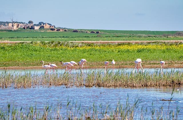
The Great Path of Malaga goes through the heart of El Chorro, therefore water is the protagonist of this site, right in the string of endorheic lagoons of the Natural Reserve of Lagunas de Campillos or in the splendid area of the Marshes, where we find Guadalhorce, Guadalteba and Conde de Guadalhorce.
The terrain where these waters are located is fairly flat, slightly inclined towards the reservoirs, and mainly composed of muddy hills where herrizas and limestone hills tower with some points emerging with plasters.
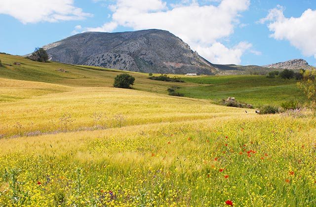
Huma Mountain, 1181 meters high, is part of the mountains that surround the marshes of El Chorro in the province of Malaga. This peculiar oval mountain shows beautiful sceneries when we observe it from afar; lost farms, gorges and ravines with completely vertical walls where climbers find their own paradise, strange rock formations in the form of stones in El Torcal de Antequera and stunning views on the top in all directions.
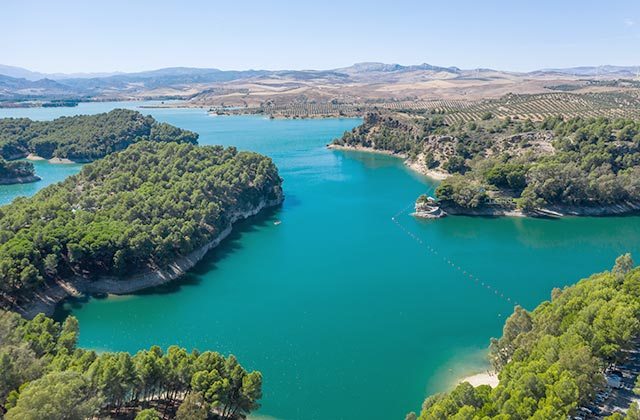
In this National Parkwe can find three reservoirs of great dimensions: Conde de Guadalhorce, Guadalhorce and Guadalteba. Although the natural surroundings is proper of Ardales, the only reservoir completely located in the municipality is Conde de Guadalhorce, with the others being located in Teba, Campillos and Antequera.
One of the most emblematic things to visit in this reservoirs is called the “Chair of the King”; which it is a set of two benches, a chair and a table all made of stone, where King Alfonso XIII signed the completion of construction of the Conde de Guadalhorce reservoir. From the chair of the king, to the other side of the reservoir we can see “Engineer House” or “Casa del Conde”, which is closed.
Also in Conde de Guadalhorce reservoir we can see the façade of the church, which was also used as a school. Another of the attractions at the reservoirs is the “Mirador”, from which you can have a bird’s eye view of the whole reservoir.
The reservoirs have several trails, where you can enjoy nature first hand. In addition, it also has camping areas, where the local museum is located.
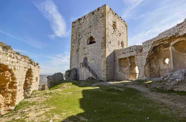
Dominating the course of the River Guadalteba and its countryside, Castillo de la Estrella rises. The town of Teba was built at its feet, with its sinuous urban layout, declared as Historical and Artistic Heritage, still keeps its popular and stately houses, like the Marques de Greñina, or the house belonging to the Empress Eugenia de Montijo, Countess of Teba. Castillo de la Estrella was built during the thirteenth century by the Almohad and throughout its occupation, suffered continuous renovations. It was built to defend the large population scattered around the Guadalteba and La Venta rivers, filled with numerous farmhouses.
The fort is one of the largest in the province of Malaga, with a surface close to 25,000 m2. Its thick walls, barbican and location made it an impregnable place.
The area of the Marshes of El Chorro offers hikers excellent picnic areas, but few have dared to climb El Mirador. As its name suggests, it offers a great view over the marshes but the food is also exquisite. La Venta is very authentic, offering a typical retail environment with local staff, curious decorations with typical motifs and plenty to see. It is not surprising to find people walking by the restaurant, observing the objects on its walls. It has different rooms and a small playground if you go with children.
Activities You Cannot Miss Out On In The El Chorro Natural Park
Olée Holiday Rentals
The best option for staying in Malaga is Fuerte Hoteles. The chain features branches where you can enjoy all of our services and the best each region has to offer. 60 years of experience are the best guarantee. Marbella or Nerja are some of the spots where you can find these great hotels.